Stratigraphic (g eochronological) scale– a geological time scale, the stages of which are highlighted by paleontology according to the development of life on Earth.
The two names of this scale have different meanings: the stratigraphic scale serves to describe the sequence and relationships of rocks that make up the earth’s crust, and the geochronological scale to describe geological time. These scales differ in terminology; you can see the differences in the table below:
|
General stratigraphic subdivisions (stratons) |
Divisions geochronological scale |
| Akrotema | Akron |
| Eonothema | Eon |
| Eratema | Era |
| System | Period |
| Department | era |
| Tier | Century |
Thus, we can say that, for example, the limestone sequence belongs to the Cretaceous system, but limestones formed in the Cretaceous period.
Systems, departments, tiers can be upper or lower, and periods, eras and centuries - early or late.
These terms should not be confused.
Phanerozoic
Phanerozoic The eon includes three eras, the names of which should be known to many: Paleozoic(era of ancient life), Mesozoic(middle life era) and Cenozoic(era of new life). Eras are in turn divided into periods. Paleozoic: Cambrian, Ordovician, Silurian, Devonian, Carboniferous, Permian; Mesozoic: Triassic, Jurassic, Cretaceous; Cenozoic: Paleogene, Neogene and Quaternary. Each period has its own letter designation and its own color for designation on geological maps.
Remembering the order of periods is quite simple using a mnemonic device. The first letter of each word in the two sentences below corresponds to the first letter of the period:
TO every ABOUT educated WITH student D olzhen TO urit P apiros. T s, YU rchik, M al, P go away N ID H inarik.
| Symbol | Color | |
| Cambrian | € | Bluish green |
| Ordovician | O | Olive |
| Silur | S | Gray-green |
| Devonian | D | Brown |
| Carbon | C | Grey |
| Permian | P | Yellow-brown |
| Triassic | T | Violet |
| Yura | J | Blue |
| Chalk | K | Light green |
| Paleogene | P* | Orange |
| Neogene | N | Yellow |
| Quaternary | Q | Yellowish gray |
*Paleogene symbol may not be displayed, because not found in all fonts: this is the ruble symbol (P with a horizontal bar)
Precambrian
Archaean And Proterozoic Akrons are the more ancient divisions, in addition, they account for most of the existence of our planet. If the Phanerozoic lasted about 530 million years, then the Proterozoic alone - more than one and a half billion years.
| Akron (acrotheme) | Eon (eonoteme) | Era (erathema) | Period (system) | era (Department) | Completion, years ago | Tectonic cycles | Basic events |
|---|---|---|---|---|---|---|---|
| Fz Phanerozoic | Kz Cenozoic | Quaternary | Holocene | Ongoing Nowadays | Alpine cycle There are only 2 belts on Earth. The Tethys Ocean is disappearing. At the end of the Neogene, glaciation began in Antarctica. Tt.o. Neogene is the largest geocratic period of the Earth. The area of the continents was larger than today. All shelf zones were part of continents. | Extinction of many large mammals. | |
| Pleistocene | 11 400 | The emergence of modern man. | |||||
| Neogene | Pliocene | 1.81 million | |||||
| Miocene | 5.33 million | ||||||
| Paleogene | Oligocene | 23.0 million | The appearance of the first apes. | ||||
| Eocene | 37.2 million | The appearance of the first "modern" mammals. | |||||
| Paleocene | 55.8 million | ||||||
| Mz Mesozoic | Chalky | 66.5 million | Pacific cycle There is 1 continent, 2 oceans and 3 zones on Earth. The dominance of land on Earth, the climate is hot and dry. The split of Gondwana is complete. | The first placental mammals. The extinction of dinosaurs. | |||
| Jurassic | 146 million | The appearance of marsupial mammals and the first birds. The rise of dinosaurs. | |||||
| Triassic | 200 million | The first dinosaurs and egg-laying mammals. | |||||
| Pz Paleozoic | Permian | 251 million | Herzing cycle In the Carboniferous there was a new supercontinent called Angaris, at which time Eria and Gondwana already existed. Eria + Angarida = Laurasia Laurasia + Gondwana = Pangea But a split immediately begins (at the end of Perm). At the end of Perm, the first great extinction of organisms occurred. | About 95% of all existing species became extinct. | |||
| Coal | 299 million | The appearance of trees and reptiles. | |||||
| Devonian | 359 million | The appearance of amphibians and spore-bearing plants. | |||||
| S Silurian | 416 million | Caledonian cycle At this stage, there were 6 ancient platforms on Earth. The largest transgression since max in the Ordovician, Gondwana remains landmass. At the beginning of the Silurian there was glaciation. At the end of the Caledonian stage, the supercontinent Eria formed. | The emergence of life onto land: scorpions and later the first plants. The appearance of fish. | ||||
| O Ordovician | 443 million | The pelagic zone is populated by cephalopods | |||||
| E Cambrian | 488 million | The emergence of a large number of new groups of organisms. | |||||
| PR Proterozoic | Rifey (Neoproterozoic) | Ediacaran (obsolete Vendian) | 542 million | Baikal cycle 5 geosynclinal belts are being established. The Pacific Ocean is formed (800 million years ago) At the end of the Riphean, all the continents of the southern hemisphere are connected - Gondwana. The climate is warm everywhere, with glaciation at the end of the Riphean. The atmosphere is saturated with oxygen (1% of current levels) | The first multicellular animals. | ||
| Cryogenium | 600 million | ||||||
| Tony | 850 million | ||||||
| Late (Mesoproterozoic) | Stenius | 1.0 billion | |||||
| Ectasy | 1.2 billion | ||||||
| Kalimium | 1.4 billion | ||||||
| Early (Paleoproterozoic) | Staterius | 1.6 billion | Karelian cycle Revolutionary stage. At the end of it, huge sections of the ZK become rigid and stable. Real platforms are formed. | ||||
| Orosirium | 1.8 billion | ||||||
| Riasiy | 2.05 billion | ||||||
| Siderius | 2.3 billion | ||||||
| AR Archaea | Late | Neoarchaean | 2.5 billion | White Sea cycle Formation of a real continental zone. | |||
| Mesoarchean | 2.8 billion | ||||||
| Early | Paleoarchaean | 3.2 billion | Soam cycle A hydrosphere is formed on Earth, which is represented by shallow oceans; the cores of the protocontinental crust exist in the form of islands. | ||||
| Eoarchaean | 3.6 billion | The emergence of primitive unicellular organisms. | |||||
| 3.8 billion | Early geological stage The formation of the Earth occurs as a result of rotation. The differentiation of the substance begins. A basaltic crust is formed, but it is phantom. | Formation of the Earth 4.57 billion years ago | |||||
Geochronological table
This is a list of time divisions or intervals, in order of their hierarchy.
Chronometric scale
This isotope age scale is based on the radioactive decay of elements from their formation to the present day.
Akron is a time period lasting 2 billion years.
An eon is a period of 1 billion years.
An era is hundreds of millions of years.
Period - tens of millions of years
Epoch - tens of millions of years.
Stratigraphic scale
This is a rock scale. Represents a complete ideal section of the Earth's crust
See also: Evolution of the geographical envelope of the earth, Geochronological scale (original article).
One of the main tasks of geological research is determining the age of the rocks that make up the earth's crust. There are relative and absolute ages. There are several methods for determining the relative age of rocks: stratigraphic and paleontological.
The stratigraphic method is based on the analysis of sedimentary rocks (marine and continental) and determination of the sequence of their formation. The layers below are older, those above are younger. This method establishes the relative age of rocks in a certain geological section in small areas.
The paleontological method consists of studying the fossilized remains of the organic world. The organic world has undergone significant changes in the course of geological history. The study of sedimentary rocks in a vertical section of the earth's crust showed that a certain complex of layers corresponds to a certain complex of plant and animal organisms.
Thus, plant and animal fossils can be used to determine the age of rocks. Fossils are the remains of extinct plants and animals, as well as traces of their vital activity. To determine the geological age, not all organisms are important, but only the so-called leading ones, that is, those organisms that, in the geological sense, did not exist for long.
Leading fossils must have a small vertical distribution, a wide horizontal distribution, and be well preserved. In each geological period, a certain group of animals and plants developed. Their fossilized remains are found in sediments of the corresponding age. In ancient layers of the earth's crust, remains of primitive organisms are found, in younger ones, highly organized ones. The development of the organic world occurred in an ascending line; from simple to complex organisms. The closer to our time, the greater the similarity with the modern organic world. The paleontological method is the most accurate and widely used.
Table composition
The geochronological scale was created to determine the relative geological age of rocks. Absolute age, measured in years, is of secondary importance to geologists. The existence of the Earth is divided into two main intervals: Phanerozoic and Precambrian (cryptozoic) according to the appearance of fossil remains in sedimentary rocks. Cryptozoic is a time of hidden life; only soft-bodied organisms existed in it, leaving no traces in sedimentary rocks. The Phanerozoic began with the appearance at the border of the Ediacaran (Vendian) and Cambrian of many species of mollusks and other organisms, allowing paleontology to subdivide the strata based on finds of fossil flora and fauna.
Another major division of the geochronological scale has its origins in the very first attempts to divide the history of the Earth into major time intervals. Then the whole history was divided into four periods: primary, which is equivalent to the Precambrian, secondary - the Paleozoic and Mesozoic, tertiary - the entire Cenozoic without the last Quaternary period. The Quaternary period occupies a special position. This is the shortest period, but many events took place in it, the traces of which are better preserved than others.
Based on stratigraphic and paleontological methods, a stratigraphic scale was constructed, presented in Fig. 1, in which the rocks that make up the earth's crust are located in a certain sequence in accordance with their relative age. This scale identifies groups, systems, departments, and tiers. Based on the stratigraphic scale, a geochronological table has been developed, in which the time of formation of groups, systems, divisions and stages is called an era, period, epoch, century.
Fig.1. Geochronological scale
The entire geological history of the Earth is divided into 5 eras: Archean, Proterozoic, Paleozoic, Mesozoic, Cenozoic. Each era is divided into periods, periods into eras, eras into centuries.
Features of determining the age of rocks
Absolute geological age is the time that has elapsed from any geological event to the modern era, calculated in absolute units of time (in billions, millions, thousands, etc. years). There are several methods for determining the absolute age of rocks.
The sedimentation method comes down to determining the amount of clastic material that is annually carried away from the surface of the land and deposited on the bottom of the sea. Knowing how much sediment accumulates on the seabed during the year and measuring the thickness of sedimentary strata accumulated in individual geological periods, one can find out the length of time required for the accumulation of these sediments.
The sedimentation method is not entirely accurate. Its inaccuracy is explained by the unevenness of sedimentation processes. The rate of sedimentation is not constant, it changes, intensifying and reaching a maximum during periods of tectonic activity of the earth's crust, when the earth's surface has highly dissected forms, due to which denudation processes intensify and, as a result, more sediment flows into marine basins. During periods of less active tectonic movements of the earth's crust, denudation processes weaken and the amount of precipitation decreases. This method gives only an approximate idea of the geological age of the Earth.
Radiological methods the most accurate methods for determining the absolute age of rocks. They are based on the use of radioactive decay of isotopes of uranium, radium, potassium and other radioactive elements. The rate of radioactive decay is constant and does not depend on external conditions. The end products of the decay of uranium are helium and lead Pb2O6. From 100 grams of uranium, 1 gram (1%) of lead is formed in 74 million years. If we determine the amount of lead (in percent) in the mass of uranium, then by multiplying by 74 million we get the age of the mineral, and from it the lifetime of the geological formation.
Recently, a radioactive method has been used, which is called potassium or argon. In this case, the potassium isotope with atomic weight 40 is used. The potassium method has the advantage that potassium is widely distributed in nature. As potassium decomposes, calcium and argon gas are formed. The disadvantage of the radiological method is the limited possibility of its use mainly for determining the age of igneous and metamorphic rocks.
Geochronological table- this is one way of representing the stages of development of planet Earth, in particular life on it. The table records eras, which are divided into periods, their age and duration are indicated, and the main aromorphoses of flora and fauna are described.
Often in geochronological tables, earlier, i.e., older, eras are recorded at the bottom, and later, i.e., younger, eras are recorded at the top. Below is data on the development of life on Earth in natural chronological order: from old to new. The tabular form has been omitted for convenience.
Archean era
It began approximately 3500 million (3.5 billion) years ago. Lasted about 1000 million years (1 billion).
In the Archean era, the first signs of life on Earth appeared - single-celled organisms.
According to modern estimates, the age of the Earth is more than 4 billion years. Before the Archean there was the Catarchean era, when there was no life yet.
Proterozoic era
It began approximately 2700 million (2.7 billion) years ago. Lasted for more than 2 billion years.
Proterozoic - the era of early life. Rare and scarce organic remains are found in the layers belonging to this era. However, they belong to all types of invertebrate animals. Also, the first chordates most likely appear - skullless.
Palaeozoic
It began about 570 million years ago and lasted more than 300 million years.
Paleozoic - ancient life. Starting with it, the process of evolution is better studied, since the remains of organisms from higher geological layers are more accessible. Hence, it is customary to examine each era in detail, noting changes in the organic world for each period (although both the Archean and the Proterozoic have their own periods).
Cambrian period (Cambrian)
Lasted about 70 million years. Marine invertebrates and algae thrive. Many new groups of organisms appear - the so-called Cambrian explosion occurs.
Ordovician period (Ordovician)
Lasted 60 million years. The heyday of trilobites and crustaceans. The first vascular plants appear.
Silurian (30 Ma)
- Coral blossom.
- The appearance of scutes - jawless vertebrates.
- The appearance of psilophyte plants coming onto land.
Devonian (60 Ma)
- The flourishing of the coryptaceae.
- Appearance of lobe-finned fishes and stegocephali.
- Distribution of higher spores on land.
Carboniferous period
Lasted about 70 million years.
- The rise of amphibians.
- The appearance of the first reptiles.
- The appearance of flying forms of arthropods.
- Decline in trilobite numbers.
- Fern blossoming.
- The appearance of seed ferns.
Perm (55 million)
- Distribution of reptiles, emergence of wild-toothed lizards.
- Extinction of trilobites.
- Disappearance of coal forests.
- Distribution of gymnosperms.
Mesozoic era
The era of middle life.
Geochronology and stratigraphy
It began 230 million years ago and lasted about 160 million years.
Triassic
Duration - 35 million years. The flourishing of reptiles, the appearance of the first mammals and true bony fish.
Jurassic period
Lasted about 60 million years.
- Dominance of reptiles and gymnosperms.
- The appearance of Archeopteryx.
- There are many cephalopods in the seas.
Cretaceous period (70 million years)
- The appearance of higher mammals and true birds.
- Wide distribution of bony fish.
- Reduction of ferns and gymnosperms.
- The emergence of angiosperms.
Cenozoic era
An era of new life. It began 67 million years ago and lasts the same amount.
Paleogene
Lasted about 40 million years.
- The appearance of tailed lemurs, tarsiers, parapithecus and dryopithecus.
- Rapid flourishing of insects.
- The extinction of large reptiles continues.
- Entire groups of cephalopods are disappearing.
- Dominance of angiosperms.
Neogene (about 23.5 million years)
Dominance of mammals and birds. The first representatives of the genus Homo appeared.
Anthropocene (1.5 Ma)
The emergence of the species Homo Sapiens. The animal and plant world takes on a modern appearance.
In 1881, at the II International Geological Congress in Bologna, the International Geochronological Scale was adopted, which is a broad systematic synthesis of the work of many generations of geologists in various fields of geological knowledge. The scale reflects the chronological sequence of time divisions during which certain complexes of sediments and the evolution of the organic world were formed, i.e. the international geochronological scale reflects the natural periodization of the history of the Earth. It is built on the principle of rank subordination of time and stratigraphic units from larger to smaller (Table 6.1). 
Each temporary division corresponds to a complex of sediments, distinguished in accordance with changes in the organic world and called a stratigraphic division.
Therefore, there are two scales: geochronological and stratigraphic (Tables 6.2, 6.3, 6.4). In these scales, the entire history of the Earth is divided into several eons and their corresponding eonotemes.
Geochronological and stratigraphic scales are constantly changing and improving. The scale given in table. 6.2, has an international rank, but it also has options: instead of the Carboniferous period on the European scale, in the USA there are two periods: the Mississippian, following the Devonian, and the Pennsylvanian, preceding the Permian.
Each era (period, epoch, etc.) is characterized by its own complex of living organisms, the evolution of which is one of the criteria for constructing a stratigraphic scale.
In 1992, the Interdepartmental Stratigraphic Committee published a modern stratigraphic (geochronological) scale, which is recommended for all geological organizations in our country (see Tables 6.2, 6.3, 6.4), but it is not generally accepted on a global scale; the greatest disagreements exist for the Precambrian and for the Quaternary system. 


Notes
Highlighted here:
1. Archean eon (AR) (ancient life), to which the stratigraphic mass of rocks corresponds - the Archean eonothem.
2. Proterozoic eon (PR) (primary life) - it corresponds to the stratigraphic strata of rocks - the Proterozoic eonothem.
3. Phanerozoic eon, divided into three eras:
3.1 - Paleozoic era (PZ) (era of ancient life) - it corresponds to the Paleozoic rock mass - Paleozoic erathema (group);
3.2 - Mesozoic era (MZ) (era of middle life) - it corresponds to the Mesozoic rock mass - Mesozoic erathema (group);
3.3 - Cenozoic era (KZ) (era of new life) - it corresponds to the Cenozoic rock formation - Cenozoic erathema (group).
The Archean eon is divided into two parts: the early (older than 3500 million years) and the late Archean. The Proterozoic eon is also divided into two parts: early and late Proterozoic; in the latter, the Riphean period (R) is distinguished (after the ancient name of the Urals - Ripheus) and the Vendian period (V) - after the name of the ancient Slavic tribe “Vedas” or “Vendas”.
The Phanerozoic eon and eonotema are divided into three eras (eratems) and 12 periods (systems). The names of the periods are usually assigned to the name of the area where they were first identified and most fully described.
In the Paleozoic era (erathema) are allocated accordingly.
1. Cambrian period (6) - Cambrian system (Є) - after the ancient name of the province of Wales in England - Cambria;
2. Ordovician period (O) - Ordovician system (O) - after the name of the ancient tribes of England that inhabited those areas - “Mordovians”;
3. Silurian period (S) - Silurian system (S) - after the name of the ancient tribes of England - “Silurians”;
4. Devonian period (D) - Devonian system (D) - after the name of the county of Devonshire in England;
5. Carboniferous (Carboniferous) period (C) - Carboniferous (Carboniferous) system (O - by the widespread development of coal deposits in these deposits;
6. Permian period (P) - Permian system (P) - after the name of the Perm province in Russia.
In the Mesozoic era (erathema) are allocated accordingly.
1. Triassic period (T) - Triassic system (T) - by dividing the period (system) into three parts;
2) Jurassic period (J) - Jurassic system (J) - named after the Jurassic Mountains in Switzerland;
3. Cretaceous period (K) - Cretaceous system (K) - according to the widespread development of writing chalk in the deposits of this system.
In the Cenozoic era (erathema) are allocated accordingly.
1. Paleogene period (P) - Paleogene system (P) - the most ancient part of the Cenozoic era;
2. Neogene period (N) - Neogene system (N) - newborns;
3. Quaternary period (Q) - Quaternary system (Q) - according to the proposal of academician.
Geochronological scale
A.A. Pavlova, sometimes called the Anthropocene.
Indices (symbols) of eras (erathems) are designated by the first two letters of Latin transcription, and periods (systems) by the first letter.
On geological maps and sections, for ease of depiction, each age system is assigned a specific color. Periods (systems) are divided accordingly into epochs (divisions). The duration of geological periods varies - from 20 to 100 million years. The exception is the Quaternary period - 1.8 million years, but it has not ended yet.
Early, middle, late eras correspond to the lower, middle, upper sections. There may be two or three eras (departments). The indices of eras (departments) correspond to the index of their periods (systems) with the addition of numbers at the bottom right - 1,2,3. For example, 5, is the Early Silurian era, and S2 is the Late Silurian era. To color designate eras (divisions), the color of their periods (systems) is used for earlier (later) - darker shades. The eras (divisions) of the Jurassic period and the Cenozoic era retained their own names. The stratigraphic and geochronological units of the Cenozoic era (groups) have their own names: P1 - Paleocene, P2 - Eocene, P3 - Oligocene, N1 - Miocene, N2 - Pliocene, QI, QII, QIII - epochs (divisions) early (lower), middle (mid-), late Quaternary (upper Quaternary) - together called the Pleistocene, and Q4 - Holocene.
The next and more fractional units of the geochronological and stratigraphic scales are centuries (stages) lasting from 2 to 10 million years. They are given geographical names.
1. Geological time scale
1.5. Geochronological and stratigraphic scales.
Irreversibility of time
3. Natural history of the Middle Ages
List of used literature
1. Geological time scale
Physical, cosmological, chemical concepts lead close to ideas about the Earth, its origin, structure and various properties. The complex of geosciences is usually called geology(Greek ge – Earth). Earth is a place and a necessary condition for the existence of humanity. For this reason, geological concepts are of the utmost importance to humans. We have to understand the nature of their evolution. Geological concepts do not arise spontaneously; they are the result of painstaking scientific research.
The Earth is a unique space object. The idea of the evolution of the Earth occupies a central place in his study. Taking this into account, let us turn, first of all, to such an important quantitative-evolutionary parameter of the Earth as its time, geological time.
The development of scientific concepts about geological time is complicated by the fact that the lifespan of a human individual is a tiny fraction of the age of the Earth (approx. 4.6 * 109 years). Simple extrapolation of current geological time into the depths of past geological time does not give anything. To obtain information about the geological past of the Earth, some special concepts are needed. There are a variety of ways to think about geological time, chief among them lithological, biostratigraphic, and radiological.
The lithological concept of geological time was first developed by the Danish physician and naturalist N. Stensen (Steno). According to the concept of Steno (1669), in a series of normally occurring strata, the overlying strata are younger than the underlying ones, and the cracks and mineral veins cutting them are even younger. Steno's main idea is this: the layered structure of the Earth's surface rocks is a spatial reflection of geological time, which, of course, also has a certain structure. In the development of Steno's ideas, geological time is determined by the accumulation of sediments in the seas and oceans, river sediments in the estuarine areas of the coast, by the height of dunes, and by the thicknesses of “ribbon” clays that appear at the edges of glaciers as a result of their melting.
In the biostratigraphic understanding of geological time, the remains of ancient organisms are taken into account: the fauna and flora lying higher are considered younger. This pattern was established by the Englishman W. Smith, who compiled the first geological map of England dividing rocks by age (1813-1815). It is important that, unlike lithological layers, biostratigraphic features extend over long distances and are present throughout the entire shell of the Earth as a whole.
Based on litho- and biostratigraphic data, attempts have been made repeatedly to create a unified (bio)stratigraphic scale of geological time. However, along this path, researchers have invariably encountered indefinable difficulties. Based on (bio)stratigraphic data, it is possible to determine the “older-younger” relationship, but it is difficult to determine how many years one layer formed before the other. But the task of ordering geological events requires the introduction of not only ordinal, but also quantitative (metric) characteristics of time.
In the radiological measurement of time, in the so-called isotope chronology, the age of geological objects is determined based on the ratio of the parent and daughter isotopes of the radioactive element in them. The idea of radiological time measurement was proposed at the beginning of the twentieth century. P. Curie and E. Rutherford.
Isotope geochronology has made it possible to use not only ordinal definitions of the “earlier-later” type in procedures for measuring geological time, but also quantitative definitions. In this regard, the geological time scale is introduced, which is usually presented in different versions. One of them is given below.
Intervals of geological time (beginnings of periods and epochs in millions of years from the present)
In the names of geological periods, only two expressions have been preserved from their early classification: Tertiary and Quaternary. Some of the names of geological periods are associated either with localities or with the nature of material deposits. So, Devonian The period characterizes the age of sediments first studied in Devonshire in England. Chalky The period characterizes the age characteristics of geological deposits containing a lot of chalk.
2. Irreversibility of time
Time – this is a form of existence of matter, expressing the order of change in objects and phenomena of reality. Characterizes the actual duration of actions, processes, events; denotes the interval between events.
Unlike space, to each point of which you can return again and again, time – irreversible And one-dimensionally. It flows from the past through the present to the future. You cannot go back to any point in time, but you cannot jump over any time period into the future. It follows that time constitutes, as it were, a framework for cause-and-effect relationships. Some argue that the irreversibility of time and its direction are determined by cause and connection, since the cause always precedes the effect. However, it is obvious that the concept of precedence already presupposes time. Therefore, G. Reichenbach is more correct when he writes: “Not only the temporal order, but also the unified space-time order is revealed as an ordering scheme governing causal chains, and thus as an expression of the causal structure of the universe.”
The irreversibility of time in macroscopic processes is embodied in the law of increasing entropy. In reversible processes, entropy remains constant, in irreversible processes it increases. Real processes are always irreversible. In a closed system, the maximum possible entropy corresponds to the onset of thermal equilibrium in it: temperature differences in individual parts of the system disappear and macroscopic processes become impossible. All the energy inherent in the system is converted into the energy of disordered, chaotic movement of microparticles, and the reverse transition of heat into work is impossible.
It turned out that time cannot be considered as something separately taken. And in any case, the measured value of time depends on the relative movement of the observers. Therefore, two observers moving relative to each other and watching two different events will come to different conclusions about how separated the events are in space and time. In 1907, the German mathematician Hermann Minkowski (1864-1909) suggested a close connection between three spatial and one temporal characteristics. In his opinion, all events in the Universe occur in a four-dimensional space-time continuum.
Geochronological scale
CLARKEY
Relief
Geographic pole
[edit]
This term has other meanings, see Pole.
Geographic pole- the point at which the Earth's axis of rotation intersects the Earth's surface. There are two geographical poles: the North Pole - located in the Arctic (the central part of the Arctic Ocean) and the South Pole - located in Antarctica.
All meridians converge at the geographic pole, and therefore the geographic pole has no longitude. The north pole has a latitude of +90 degrees, and the south pole has a latitude of −90 degrees.
There are no cardinal directions at the geographic poles. There is no change of day and night at the poles, since the poles do not participate in the daily rotation of the Earth.
At the geographic pole, the angle of elevation of the Sun does not exceed 23.5°, which is why the temperature at the pole is very low.
The position of the geographic poles is conditional, since the instantaneous axis of rotation of the Earth moves. Because of this, the movement of geographical poles occurs.
[edit]See Also
Magnetic pole- a conventional point on the earth’s surface at which the earth’s magnetic field is directed strictly at an angle of 90° to the surface.
[edit]
Material from Wikipedia - the free encyclopedia
This term has other meanings, see Relief (meanings).
Layout with terrain relief
Relief(fr.
Posted on ref.rf
relief, from lat. relevo- lift) - a set of irregularities on land, the bottom of oceans and seas, varied in outline, size, origin, age and history of development. It is made up of positive (convex) and negative (concave) shapes.
Relief is formed mainly as a result of long-term simultaneous effects on the earth's surface of endogenous (internal) and exogenous (external) processes. Relief is studied by geomorphology.
The main forms of relief are mountain, basin, ridge, and hollow.
On large-scale topographic and sports maps, the relief is depicted with isohypses - horizontal lines, numerical marks and additional symbols. On small-scale topographic and physical maps, relief is indicated by color (hypsometric coloring with clear or blurred steps) and shading.
Denudation plains appear on the site of destroyed mountains.
Posted on ref.rf
Accumulative plains are formed during the long-term accumulation of layers of loose sedimentary rocks at the site of extensive subsidence of the earth's surface.
Fold mountains are uplifts of the earth's surface that arise in moving zones of the earth's crust, most often at the edges of lithospheric plates. Block mountains arise as a result of the formation of horsts, grabens and the movement of sections of the earth's crust along faults. Folded block mountains appeared on the site of sections of the earth's crust that in the past underwent mountain building, transformation into a denudation plain, and repeated mountain building. Volcanic mountains are formed during volcanic eruptions.
Hypsographic curve(from ancient Greek ὕψος - ʼʼheightʼʼ and γράφω ʼʼI writeʼʼ, also hypsometric curve) - empirical integral function of distribution of ocean depths and heights of the earth's surface. It is usually depicted on a coordinate plane, where the height of the relief is plotted along the vertical axis, and the proportion of the surface whose relief height is greater than the specified one is plotted along the horizontal axis. The part of the curve located below sea level is called the bathygraphic curve.
The hypsographic curve was first constructed in 1883 by A. Lapparan and refined in 1933 by E. Kossina. Refinements for the bathygraphic curve were made in 1959 by V. N. Stepanov.
The hypsographic curve of the Earth's relief has two flat sections: one of them at sea level, the other at a depth of 4-5 km. These areas correspond to the presence of two rocks of different densities. The flat section at sea level corresponds to light rocks consisting of granite (density 2800 kg/m³), the lower section corresponds to heavy rocks composed of basalts (3300 kg/m³). Unlike the Earth, the hypsographic curve of the Moon does not contain flat sections, which indicates the absence of differentiation of rocks.
CLARKEY elements, numbers expressing the average chemical content. elements in the earth's crust, hydrosphere, the Earth as a whole, cosmic. bodies, etc.
Posted on ref.rf
geochem. or cosmochemical systems. There are weights (in%, in G/T or in g/ G) and atomic (% of the number of atoms) clarkes. Generalization of data on chemistry. composition of various rocks that make up the earth's crust, taking into account their distribution to depths of 16 km m was first made by Amer.
Posted on ref.rf
scientist F.W. Clark(1889). The figures he obtained for the percentage of chemicals. The elements in the composition of the earth's crust, subsequently somewhat refined by A.E. Fersman, at the latter's suggestion, were called Clarke numbers, or clarke numbers. Average contents of elements in the earth's crust, in modern times.
Posted on ref.rf
understanding it as the upper layer of the planet above the Mohorovicic boundary (see. Mohorovicic surface), calculated by A.P. Vinogradov(1962), Amer.
Posted on ref.rf
scientist S. R. Taylor (1964), German. - K. G. Vedepol (1967) (see table). Elements of small serial numbers predominate: 15 of the most common elements, the clarks of which are above 100 g/ T, have serial numbers up to 26 (Fe). Elements with even serial numbers make up 87% of the mass of the earth's crust, and those with odd numbers make up only 13%. Average chem. The composition of the Earth as a whole was calculated based on data on the content of elements in meteorites (see. Geochemistry).
Since K. elements serve as a standard for comparing reduced or increased concentrations of chemicals. elements in mineral deposits, rocks or entire regions, knowledge of them is important when searching and industrial. assessment of mineral deposits; they also make it possible to judge the violation of the usual relationships between similar elements (chlorobromine, niobium - tantalum) and thereby indicate different physical-chemical properties. factors that disrupt these equilibrium relationships.
In processes element migration K. Elements are quantities, an indicator of their concentration.
The earth's crust contains many elements, but its main part is oxygen and silicon.
The average values of chemical elements in the earth's crust are called clarks. The name was introduced by the Soviet geochemist A.E. Fersman in honor of the American geochemist Frank Wiglesworth Clark, who, after analyzing the results of thousands of rock samples, calculated the average composition of the earth's crust. Clark's calculated composition of the earth's crust was close to granite, a common igneous rock in the Earth's continental crust.
After Clark, the Norwegian geochemist Victor Goldschmidt began determining the average composition of the earth's crust. Goldschmidt made the assumption that the glacier, moving along the continental crust, scrapes off and mixes the rocks that come to the surface. For this reason, glacial deposits or moraines reflect the average composition of the earth's crust. By analyzing the composition of the ribbon clays deposited on the bottom of the Baltic Sea during the last glaciation, the scientist obtained the composition of the earth's crust, which was very similar to the composition of the earth's crust calculated by Clark.
Subsequently, the composition of the earth's crust was studied by Soviet geochemists Alexander Vinogradov, Alexander Ronov, Alexei Yaroshevsky, and the German scientist G. Wedepohl.
After analyzing all scientific works, it was found that the most common element in the earth’s crust is oxygen. His clarke is 47%. The next most abundant chemical element after oxygen is silicon with a clarke of 29.5%. Other common elements are: aluminum (clarke 8.05), iron (4.65), calcium (2.96), sodium (2.5), potassium (2.5), magnesium (1.87) and titanium (0.45). Taken together, these elements make up 99.48% of the entire composition of the earth’s crust; they form numerous chemical compounds. The Clarks of the remaining 80 elements are only 0.01-0.0001 and therefore such elements are called rare. If an element is not only rare, but also has a weak ability to concentrate, it is called rare scattered.
In geochemistry, the term “microelements” is also used, which means elements whose clarke in a given system is less than 0.01. A.E. Fersman plotted the dependence of atomic clarkes for even and odd elements of the periodic table. It was revealed that as the structure of the atomic nucleus becomes more complex, the clarke values decrease. But the lines constructed by Fersman turned out to be not monotonous, but broken. Fersman drew a hypothetical middle line: he called the elements located above this line excess (O, Si, Ca, Fe, Ba, Pb, etc.), below - deficient (Ar, He, Ne, Sc, Co, Re etc.).
You can get acquainted with the distribution of the most important chemical elements in the earth's crust using this table:
Age of the Earth- time has passed since the formation of the Earth as an independent planet. According to modern scientific data, the age of the Earth is 4.54 billion years (4.54·10 9 years ± 1%). These data are based on radioisotope dating of not only terrestrial samples, but also meteorite matter. Οʜᴎ were obtained primarily using the lead-lead method. This figure corresponds to the age of the oldest Earth and lunar samples.
After the scientific revolution and the development of radioisotope dating methods, it turned out that many mineral samples are over a billion years old. The oldest found so far are small zircon crystals from the Jack Hills in Western Australia - their age is at least 4404 million years. Based on a comparison of the mass and luminosity of the Sun and other stars, it was concluded that the Solar System should not be much older than these crystals. The calcium- and aluminum-rich nodules found in meteorites are the oldest known samples to have formed within the Solar System, at 4,567 million years old, providing an estimate of the age of the Solar System and an upper limit on the age of the Earth. There is a hypothesis that the accretion of the Earth began shortly after the formation of calcium-aluminum nodules and meteorites. Because the exact time of Earth's accretion is unknown and various models give anywhere from a few million to 100 million years, the exact age of the Earth is difficult to determine. At the same time, it is difficult to determine the absolutely exact age of the oldest rocks exposed on the surface of the Earth, since they are composed of minerals of different ages.
Time in geology
Determining the age of rocks is based on studying the sequence of formation of strata in the earth's crust. Based on data on organic remains, composition, structure and location of layers relative to each other in the vertical and horizontal directions, a geochronological scale has been developed that reflects the geological history of the Earth. In accordance with the geochronological scale, a stratigraphic scale has been created, which indicates rock complexes formed during geological periods of time. Below is the relationship between the basic geochronological and stratigraphic units, ᴛ.ᴇ. intervals of geological time and rock complexes formed in the corresponding time interval. Geological time interval: Era-Period-Era-Century The complex of rocks formed during this interval: Group-System-Department-Tier Thus, during an era a complex of rocks called a group was formed, during a period a complex of rocks called a system was formed, etc. On the geochronological scale (Table 2.1.1.3.1), there are five largest intervals of geological time - eras, each of which is divided into periods, and each period into epochs. Geochronological scales are also compiled with more fractional chronological intervals: epochs are divided into centuries. Divisions of a stratigraphic scale usually have the same names. For example, the Cenozoic era corresponds to the Cenozoic group of rocks, and during the Neogene period complexes of rocks of the Neogene system were formed, etc. Moreover, the names of the eras often do not coincide with the names of the departments.
|
Determining the relative age of rocks - this is an establishment of which rocks formed earlier and which later. Relative age of sedimentary ᴦ.p. is established using geological-stratigraphic (stratigraphic, lithological, tectonic, geophysical) and biostratigraphic methods. The stratigraphic method is based on the fact that the age of a layer at normal occurrence is determined - the underlying layers are more ancient, and the overlying ones are younger. This method should also be used for folded layers. It should not be used with overturned folds. The lithological method is based on the study and comparison of the composition of rocks in different outcrops (natural - on the slopes of rivers, lakes, seas, artificial - quarries, pits, etc.). In a limited area, sediments of the same material composition (ᴛ.ᴇ. consist of the same minerals and rocks) are of the same age. When comparing sections of various outcrops, marker horizons are used, which are clearly distinguished from other rocks and are stratigraphically consistent over a large area. The tectonic method is based on the fact that powerful deformation processes ᴦ.p. appear (as a rule) simultaneously over large areas; therefore, strata of the same age have approximately the same degree of dislocation (displacement). In the history of the Earth, sedimentation periodically gave way to folding and mountain building. The mountainous regions that emerged were destroyed, and the sea again invaded the leveled territory, at the bottom of which strata of new sedimentary deposits were already accumulating unconformably. in this case, various unconformities serve as boundaries dividing sections into separate strata. Geophysical methods are based on the use of physical characteristics of sediments (resistivity, natural radioactivity, remanent magnetization, etc.) when dividing them into layers and comparing them. Division rocks in boreholes based on resistivity measurements ᴦ.p. and porosity is usually called electrical logging, based on measurements of their radioactivity - gamma logging. Study of remanent magnetization ᴦ.p. called the paleomagnetic method; it is based on the fact that magnetic minerals, when precipitated, spread out in accordance with the magnetic field of the Earth of that era, which, as is known, was constantly changing over geological time. This orientation is permanently preserved if the rock is not subjected to heating above 500C (the so-called Curie point) or intense deformation and recrystallization. Consequently, in different layers the direction of the magnetic field will be different. Paleomagnetism allows thus. compare deposits that are significantly distant from each other (the western coast of Africa and the eastern coast of Latin America). Biostratigraphic or paleontological methods consist of determining the age of ᴦ.p. through the study of fossil organisms (paleontological methods will be discussed in detail in the next lecture). Determination of the relative age of magmas. And metam. G.p. (ever higher character.
Posted on ref.rf
Methods - for determining the age of sedimentary rocks) is complicated by the lack of paleontological remains. The age of effusive rocks occurring together with sedimentary rocks is determined by the ratio to sedimentary rocks. The relative age of intrusive rocks is determined by the ratio of igneous rocks and host sedimentary rocks, the age of which is established. Determining the relative age of metathromic rocks is similar to determining the relative age of igneous rocks.
[edit]
Material from Wikipedia - the free encyclopedia
| Geochronological scale | |||
| Eon | Era | Period | |
| P h a n e r o s e | Cenozoic | Quaternary | |
| Neogene | |||
| Paleogene | |||
| Mesozoic | Chalk | ||
| Yura | |||
| Triassic | |||
| Paleozoic | Permian | ||
| Carbon | |||
| Devonian | |||
| Silur | |||
| Ordovician | |||
| Cambrian | |||
| DOCEMBRIA | Proterozoic | Neo-Proterozoic | Ediacaran |
| Cryogenium | |||
| Tony | |||
| Meso-Proterozoic | Stenius | ||
| Ectasy | |||
| Kalimium | |||
| Paleo-Proterozoic | Staterius | ||
| Orosirium | |||
| Riasiy | |||
| Siderius | |||
| A r h e y | Neoarchaean | ||
| Mesoarchean | |||
| Paleoarchaean | |||
| Eoarchaean | |||
| Katarhey | |||
| Source |
Geochronological scale- a geological time scale of the history of the Earth, used in geology and paleontology, a kind of calendar for periods of time of hundreds of thousands and millions of years.
According to modern generally accepted ideas, the age of the Earth is estimated at 4.5-4.6 billion years. No rocks or minerals have been found on the Earth's surface that could have witnessed the formation of the planet. The maximum age of the Earth is limited by the age of the earliest solid formations in the Solar System - refractory inclusions rich in calcium and aluminum (CAI) from carbonaceous chondrites. The age of CAI from the Allende meteorite, according to the results of modern studies by the U-Pb isotope method, is 4568.5 ± 0.5 million years. This is currently the best estimate of the age of the Solar System. The time of formation of the Earth as a planet must be millions and even many tens of millions of years later than this date.
Subsequent time in the history of the Earth was divided into various time intervals according to the most important events that then occurred.
The boundary between the eras of the Phanerozoic passes through the largest evolutionary events - global extinctions. The Paleozoic is separated from the Mesozoic by the largest extinction event in Earth history, the Permo-Triassic extinction event. The Mesozoic is separated from the Cenozoic by the Cretaceous-Paleogene extinction event.
Geochronological scale depicted as a spiral
[edit] History of the creation of the scale
In the second half of the 19th century, at the II-VIII sessions of the International Geological Congress (IGC) in 1881-1900. the hierarchy and nomenclature of most modern geochronological divisions were adopted. Subsequently, the International Geochronological (Stratigraphic) Scale was constantly refined.
Specific names were given to periods based on various characteristics. Most often, geographical names were used. Thus, the name of the Cambrian period comes from the Latin. Cambria- the names of Wales when it was part of the Roman Empire, Devonian - the county of Devonshire in England, Permian - from ᴦ. Perm, Jurassic - from the Jura Mountains in Europe. The Vendian (Vendians is the German name for the Slavic people of the Lusatian Sorbs), Ordovician and Silurian (Celtic tribes Ordovicians and Silurians) periods are named after the ancient tribes. Names related to the composition of the rocks were used less frequently. The Carboniferous period is named because of the large number of coal seams, and the Cretaceous period is named because of the widespread occurrence of writing chalk.
[edit] The principle of constructing a scale
The geochronological scale was created to determine the relative geological age of rocks. Absolute age, measured in years, is of secondary importance to geologists.
The existence of the Earth is divided into two main intervals (eons): Phanerozoic and Precambrian (Cryptozoic) according to the appearance of fossil remains in sedimentary rocks. Cryptozoic is a time of hidden life; only soft-bodied organisms existed in it, leaving no traces in sedimentary rocks. The Phanerozoic began with the appearance on the border of the Ediacaran (Vendian) and Cambrian of many species of mollusks and other organisms, allowing paleontology to dissect the strata based on finds of fossil flora and fauna.
Another major division of the geochronological scale has its origin in the very first attempts to divide the history of the earth into major time intervals. Then the whole history was divided into four periods: primary, which is equivalent to the Precambrian, secondary - Paleozoic and Mesozoic, tertiary - the entire Cenozoic without the last Quaternary period. The Quaternary period occupies a special position. This is the shortest period, but many events took place in it, the traces of which are better preserved than others.
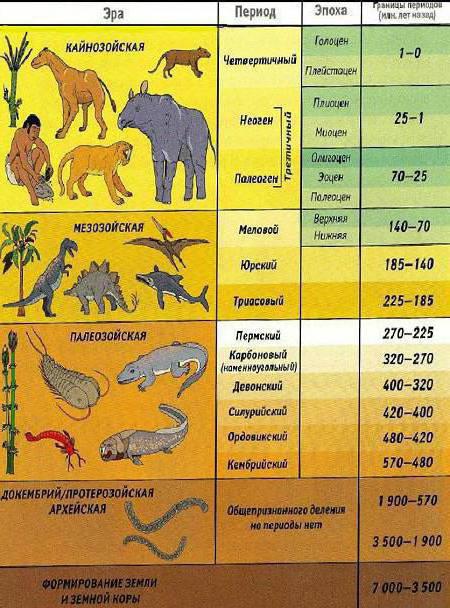
| Aeon (eonoteme) | Era (erathema) | Period (system) | Epoch (department) | Start, years ago | Main events |
| Phanerozoic | Cenozoic | Quaternary (anthropogenic) | Holocene | 11.7 thousand | The end of the Ice Age. The emergence of civilizations |
| Pleistocene | 2.588 million | Extinction of many large mammals. The emergence of modern man | |||
| Neogene | Pliocene | 5.33 million | |||
| Miocene | 23.0 million | ||||
| Paleogene | Oligocene | 33.9 ± 0.1 million | The appearance of the first apes. | ||
| Eocene | 55.8 ± 0.2 million | The appearance of the first “modern” mammals. | |||
| Paleocene | 65.5 ± 0.3 million | ||||
| Mesozoic | Chalky | 145.5 ± 0.4 million | The first placental mammals. The extinction of dinosaurs. | ||
| Jurassic | 199.6 ± 0.6 million | The appearance of marsupial mammals and the first birds. The Rise of the Dinosaurs. | |||
| Triassic | 251.0 ± 0.4 million | The first dinosaurs and egg-laying mammals. | |||
| Paleozoic | Permian | 299.0 ± 0.8 million | About 95% of all existing species became extinct (Permian Mass Extinction). | ||
| Coal | 359.2 ± 2.8 million | The appearance of trees and reptiles. | |||
| Devonian | 416.0 ± 2.5 million | The appearance of amphibians and spore-bearing plants. | |||
| Silurian | 443.7 ± 1.5 million | Exit of life to land: scorpions; appearance of gnathostomes | |||
| Ordovician | 488.3 ± 1.7 million | Racoscorpions, the first vascular plants. | |||
| Cambrian | 542.0 ± 1.0 million | The emergence of a large number of new groups of organisms (the Cambrian Explosion). | |||
| Precambrian | Proterozoic | Neoproterozoic | Ediacaran | ~635 million | The first multicellular animals. |
| Cryogenium | 850 million | One of the largest glaciations on Earth | |||
| Tony | 1.0 billion | The beginning of the collapse of the supercontinent Rodinia | |||
| Mesoproterozoic | Stenius | 1.2 billion | Supercontinent Rodinia, superocean Mirovia | ||
| Ectasy | 1.4 billion | The first multicellular plants (red algae) | |||
| Kalimium | 1.6 billion | ||||
| Paleoproterozoic | Staterius | 1.8 billion | |||
| Orosirium | 2.05 billion | ||||
| Riasiy | 2.3 billion | ||||
| Siderius | 2.5 billion | Oxygen disaster | |||
| Archaea | Neoarchaean | 2.8 billion | |||
| Mesoarchean | 3.2 billion | ||||
| Paleoarchaean | 3.6 billion | ||||
| Eoarchaean | 4 billion | The emergence of primitive single-celled organisms | |||
| Katarhey | ~4.6 billion | ~4.6 billion years ago - formation of the Earth. |
[edit]Scale diagrams of the geochronological scale
Three chronograms are presented, reflecting different stages of the history of the earth on different scales.
1. The top diagram covers the entire history of the earth;
2. The second is the Phanerozoic, a time of mass emergence of various forms of life;
3. Bottom - Cenozoic, the period of time after the extinction of the dinosaurs.
Millions of years
Geochronological scale - concept and types. Classification and features of the category "Geochronological scale" 2017, 2018.
Stratigraphic scale (geochronological) is a standard by which the history of the Earth is measured in terms of time and geological values. is a kind of calendar that counts periods of time in hundreds of thousands and even millions of years.
About the planet
Modern generally accepted ideas about the Earth are based on various data, according to which the age of our planet is approximately four and a half billion years. Neither rocks nor minerals that could indicate the formation of our planet have yet been discovered either in the depths or on the surface. Refractory compounds rich in calcium, aluminum and carbonaceous chondrites, which were formed earlier in the Solar System, limit the maximum age of the Earth to these figures. The stratigraphic scale (geochronological) shows the boundaries of time from the formation of the planet.
A variety of meteorites were studied using modern methods, including uranium-lead, and as a result, estimates of the age of the Solar System were presented. As a result, the time that has passed since the creation of the planet was divided into time intervals according to the most important events for the Earth. The geochronological scale is very convenient for tracking geological times. The Phanerozoic eras, for example, are delimited by major evolutionary events when the global extinction of living organisms occurred: the Paleozoic on the border with the Mesozoic was marked by the largest extinction of species in the entire history of the planet (Permo-Triassic), and the end of the Mesozoic was separated from the Cenozoic by the Cretaceous-Paleogene extinction.
History of creation
For the hierarchy and nomenclature of all modern subdivisions of geochronology, the nineteenth century turned out to be the most important: in its second half, sessions of the International Geological Congress (IGC) took place. After this, from 1881 to 1900, the modern stratigraphic scale was compiled.
Its geochronological “filling” was subsequently repeatedly refined and modified as new data became available. Completely different characteristics have served as themes for specific names, but the most common factor is geographic.

Titles
The geochronological scale sometimes connects the names with the geological composition of the rocks: Carboniferous appeared due to the huge number of coal seams during excavations, and Cretaceous - simply because writing chalk spread throughout the world.
Construction principle
To determine the relative geological age of the rock, a special geochronological scale was needed. Eras, periods, that is, ages, which are measured in years, are of little importance to geologists. The entire life of our planet was divided into two main periods - the Phanerozoic and Cryptozoic (Precambrian), which are delimited by the appearance of fossil remains in sedimentary rocks.
Cryptozoic is the most interesting thing hidden from us, since the soft-bodied organisms that existed at that time did not leave a single trace in sedimentary rocks. Periods of the geochronological scale, such as the Ediacaran and Cambrian, appeared in the Phanerozoic through the research of paleontologists: they found in the rock a large variety of mollusks and many species of other organisms. Findings of fossil fauna and flora allowed them to subdivide the strata and give them appropriate names.
Time intervals
The second largest division is an attempt to designate the historical intervals of the Earth's life, when the four main periods were divided by the geochronological scale. The table shows them as primary (Precambrian), secondary (Paleozoic and Mesozoic), tertiary (almost the entire Cenozoic) and Quaternary - a period that is in a special position because, although it is the shortest, it is replete with events that left bright and clearly readable traces.
Now, for convenience, the geochronological scale of the Earth is divided into 4 eras and 11 periods. But the last two of them are divided into 7 more systems (epochs). No wonder. The last segments are especially interesting, since this corresponds to the time of the emergence and development of humanity.

Major milestones
Over four and a half billion years in the history of the Earth, the following events occurred:
- Pre-nuclear organisms (the first prokaryotes) appeared four billion years ago.
- The ability of organisms to photosynthesize was discovered three billion years ago.
- Cells with a nucleus (eukaryotes) appeared two billion years ago.
- Multicellular organisms evolved one billion years ago.
- The ancestors of insects appeared: the first arthropods, arachnids, crustaceans and other groups - 570 million years ago.
- Fish and proto-amphibians are five hundred million years old.
- Land plants appeared and have been delighting us for 475 million years.
- Insects have lived on earth for four hundred million years, and plants received seeds during the same time period.
- Amphibians have lived on the planet for 360 million years.
- Reptiles (creeping things) appeared three hundred million years ago.
- Two hundred million years ago the first mammals began to develop.
- One hundred and fifty million years ago, the first birds tried to explore the sky.
- One hundred and thirty million years ago, flowers (flowering plants) bloomed.
- Sixty-five million years ago, the Earth lost the dinosaurs forever.
- Two and a half million years ago, humans (genus Homo) appeared.
- One hundred thousand years have passed since the beginning of anthropogenesis, thanks to which people acquired their current appearance.
- Neanderthals have not existed on Earth for twenty-five thousand years.
The geochronological scale and the history of the development of living organisms, merged together, albeit somewhat schematically and generally, with rather approximate dating, but provide a clear idea of the development of life on the planet.

Rock bedding
The Earth's crust is mostly stratified (where no disturbances have occurred due to earthquakes). The general geochronological scale is compiled according to the location of the strata of rocks, which clearly show how their age decreases from lower to upper.
Fossil organisms also change as they move up: they become more and more complex in their structure, some undergo significant changes from layer to layer. This can be observed without visiting paleontological museums, but simply by going down the subway - eras that are very distant from us have left their imprints on the facing granite and marble.

Anthropocene
The last period of the Cenozoic era is the modern stage of earth's history, including the Pleistocene and Holocene. What happened during these tumultuous millions of years (experts still estimate differently: from six hundred thousand to three and a half million). There were repeated changes in cooling and warming, huge continental glaciations, when the climate moistened to the south of the advancing glaciers, and water basins, both fresh and salt, appeared. Glaciers absorbed part of the World Ocean, the level of which dropped by a hundred meters or more, due to which connections of continents were formed.
Thus, an exchange of fauna took place, for example, between Asia and North America, when a bridge was formed instead of the Bering Strait. Cold-loving animals and birds settled closer to the glaciers: mammoths, hairy rhinoceroses, reindeer, musk oxen, arctic foxes, and polar partridges. They spread very far south - to the Caucasus and Crimea, to Southern Europe. Along the course of the glaciers, relict forests are still preserved: pine, spruce, and fir. And only at a distance from them did deciduous forests grow, consisting of trees such as oak, hornbeam, maple, and beech.
Pleistocene and Holocene
This is the era after the Ice Age - an unfinished and incompletely lived segment of the history of our planet, which is designated by the international geochronological scale. The anthropogenic period is the Holocene, calculated from the last continental glaciation (northern Europe). It was then that the land and the World Ocean received their modern outlines, and all the geographical zones of the modern Earth took shape. The predecessor of the Holocene, the Pleistocene, is the first epoch of the anthropogenic period. The cooling that has begun on the planet continues - the main part of this period (the Pleistocene) was marked by a much colder climate than the modern one.
The Northern Hemisphere is experiencing the last glaciation - the surface of glaciers was thirteen times larger than modern formations, even during interglacial intervals. Pleistocene plants are closest to modern ones, but they were located somewhat differently, especially during periods of glaciation. The genera and species of fauna changed, and those adapted to the Arctic form of life survived. The southern hemisphere did not experience such huge upheavals, so the plants and fauna of the Pleistocene are still present in many species. It was in the Pleistocene that the evolution of the genus Homo took place - from (archanthropes) to Homo sapiens (neoanthropes).
When did mountains and seas appear?
The second period of the Cenozoic era - the Neogene and its predecessor - the Paleogene, which included the Pliocene and Miocene about two million years ago, lasted approximately sixty-five million years. In the Neogene, the formation of almost all mountain systems was completed: the Carpathians, Alps, Balkans, Caucasus, Atlas, Cordillera, Himalayas and so on. At the same time, the outlines and sizes of all sea basins changed, as they were subjected to severe drainage. It was then that Antarctica and many mountainous regions froze.
Marine inhabitants (invertebrates) had already become close to modern species, and on land mammals dominated - bears, cats, rhinoceroses, hyenas, giraffes, deer. Apes develop so much that a little later (in the Pliocene) australopithecines could appear. On the continents, mammals lived separately, since there was no connection between them, but in the late Miocene, Eurasia and North America nevertheless exchanged fauna, and at the end of the Neogene, the fauna migrated from North America to South America. It was then that tundra and taiga formed in the northern latitudes.

Paleozoic and Mesozoic eras
The Mesozoic era precedes the Cenozoic era and lasted 165 million years, including the Cretaceous, Jurassic and Triassic periods. At this time, mountains were intensively formed on the peripheries of the Indian, Atlantic and Pacific oceans. Reptiles began their dominance on land, in water, and in the air. At the same time, the first, still very primitive mammals appeared.
The Paleozoic is located on the scale before the Mesozoic. It lasted about three hundred and fifty million years. This is the time of the most active mountain building and the most intense evolution of all higher plants. Almost all known invertebrates and vertebrates of various types and classes were formed then, but there were no mammals and birds yet.
Proterozoic and Archaean
The Proterozoic era lasted about two billion years. At this time, sedimentation processes were active. Blue-green algae developed well. There was no opportunity to learn more about these distant times.
The Archean is the oldest era in the documented history of our planet. It lasted about a billion years. As a result of active volcanic activity, the very first living microorganisms appeared.


